| |
| U.S. Route 52 | |

| |
| Comprimento: | 2 072[1] mi (3 335 km) |
|---|---|
| Construído: | 1926 (99 anos)[1] |
| Oeste | SK-39 em Portal |
| Principais ligações |
|
| Este | |
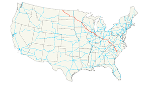
U.S. Route 52 (ou U.S. Highway 52) é uma autoestrada dos Estados Unidos.
Faz a ligação do Oeste para o Este. A U.S. Route 52 foi construída em 1926 e tem 2 072 milhas (3 335 km).
Principais ligações
![]() Autoestrada 94 em Jamestown
Autoestrada 94 em Jamestown
![]() Autoestrada 35W em Minneapolis
Autoestrada 35W em Minneapolis
![]() Autoestrada 35E em Saint Paul
Autoestrada 35E em Saint Paul
![]() Autoestrada 80 em Joliet
Autoestrada 80 em Joliet
![]()
![]() Autoestrada 69/Autoestrada 70 em Indianapolis
Autoestrada 69/Autoestrada 70 em Indianapolis
![]() Autoestrada 75 em Cincinnati
Autoestrada 75 em Cincinnati
![]() Autoestrada 81 em Wytheville
Autoestrada 81 em Wytheville
![]() Autoestrada 40 em Winston-Salem
Autoestrada 40 em Winston-Salem
![]() Autoestrada 95 perto de Florence
Autoestrada 95 perto de Florence
Ver também
- Autoestradas dos Estados Unidos
Referências
- ↑ 1,0 1,1 (em inglês) US Highways From US 1 to US 830 Robert V. Droz.
| U.S. Routes | |||||||||||||||||||
| 1 | 2 | 3 | 4 | 5 | 6 | 7 | 8 | 9 | 10 | ||||||||||
| 11 | 12 | 13 | 14 | 15 | 16 | 17 | 18 | 19 | 20 | ||||||||||
| 21 | 22 | 23 | 24 | 25 | 26 | 27 | 28 | 29 | 30 | ||||||||||
| 31 | 32 | 33 | 34 | 35 | 36 | 37 | 38 | 40 | |||||||||||
| 41 | 42 | 43 | 44 | 45 | 46 | 48 | 49 | 50 | |||||||||||
| 51 | 52 | 53 | 54 | 55 | 56 | 57 | 58 | 59 | 60 | ||||||||||
| 61 | 62 | 63 | 64 | 65 | 66 | 67 | 68 | 69 | 70 | ||||||||||
| 71 | 72 | 73 | 74 | 75 | 76 | 77 | 78 | 79 | 80 | ||||||||||
| 81 | 82 | 83 | 84 | 85 | 87 | 89 | 90 | ||||||||||||
| 91 | 92 | 93 | 94 | 95 | 96 | 97 | 98 | 99 | |||||||||||
| 101 | 163 | 400 | |||||||||||||||||
| 412 | 425 | ||||||||||||||||||


 " class="attachment-atbs-s-4_3 size-atbs-s-4_3 wp-post-image" alt="O que estudar para o enem 2023">
 " class="attachment-atbs-s-4_3 size-atbs-s-4_3 wp-post-image" alt="Qual melhor curso para fazer em 2023">
 " class="attachment-atbs-s-4_3 size-atbs-s-4_3 wp-post-image" alt="Enem: Conteúdos E Aulas On-Line São Opção Para Os Estudantes">
 " class="attachment-atbs-s-4_3 size-atbs-s-4_3 wp-post-image" alt="Como Fazer Uma Carta De Apresentação">
 " class="attachment-atbs-s-4_3 size-atbs-s-4_3 wp-post-image" alt="Como Escrever Uma Boa Redação">
 " class="attachment-atbs-s-4_3 size-atbs-s-4_3 wp-post-image" alt="Concurso INSS edital 2022 publicado">


