
Tamanho desta visualização em PNG deste arquivo em SVG: 533 × 600 pixels. Outras resoluções: 213 × 240 pixels | 427 × 480 pixels | 683 × 768 pixels | 910 × 1 024 pixels | 1 821 × 2 048 pixels | 1 161 × 1 306 pixels.
Imagem numa resolução maior (arquivo SVG, de 1 161 × 1 306 pixels, tamanho: 1,38 MB)
Descrição do arquivo
| Descrição |
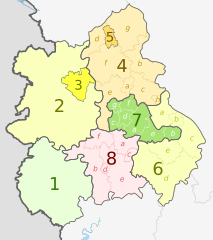
English: Map of the West Midlands region of England, showing its counties and administrative districts. The county colours are the same as those in File:English metropolitan and non-metropolitan counties 2009.svg.
Equirectangular map projection on WGS 84 datum, with N/S stretched 165% Geographic limits:
|
| Data | (UTC) |
| Fonte |
Este arquivo foi derivado de: |
| Autor |
|
| Outras versões |
 |


| Map | Ceremonial county | Shire county / unitary | Districts |
|---|---|---|---|
 |
1. Herefordshire U.A. | ||
| Shropshire | 2. Shropshire U.A. | ||
| 3. Telford and Wrekin U.A. | |||
| Staffordshire | 4. Staffordshire † | a) Cannock Chase, b) East Staffordshire, c) Lichfield, d) Newcastle-under-Lyme, e) South Staffordshire, f) Stafford, g) Staffordshire Moorlands, h) Tamworth | |
| 5. Stoke-on-Trent U.A. | |||
| 6. Warwickshire † | a) North Warwickshire, b) Nuneaton and Bedworth, c) Rugby, d) Stratford-on-Avon, e) Warwick | ||
| 7. West Midlands * | a) Birmingham, b) Coventry, c) Dudley, d) Sandwell, e) Solihull, f) Walsall, g) Wolverhampton | ||
| 8. Worcestershire † | a) Bromsgrove, b) Malvern Hills, c) Redditch, d) Worcester, e) Wychavon, f) Wyre Forest | ||
Key: †shire county | *metropolitan county
Licenciamento
A utilização deste arquivo é regulada nos termos da licença Creative Commons Atribuição-Partilha nos Termos da Mesma Licença 3.0 Unported.
Atribuição: Dr Greg and Nilfanion. Contains Ordnance Survey data © Crown copyright and database right 2011
- Você é livre:
- para compartilhar – copiar, distribuir e transmitir a obra
- para remixar – para adaptar o trabalho
- Sob as seguintes condições:
- atribuição – Você deve dar crédito apropriado, fornecer um link para a licença e indicar se as alterações foram feitas. Você pode fazê-lo de qualquer maneira razoável, mas não de maneira alguma que sugira que o licenciador endossa você ou seu uso.
- compartilhar igualmente – Se você remixar, transformar ou construir sobre o material, você deve distribuir suas contribuições sob a licença igual ou compatível como o original.
Registro de upload original
This image is a derivative work of the following images:
- File:West_Midlands_districts_2011_map.svg licensed with Cc-by-sa-3.0, GFDL
- 2011-05-01T19:06:46Z Nilfanion 1161x1306 (1392730 Bytes) == Summary == {{Information |Description=Map of the [[w:West Midlands|West Midlands]] region showing the administrative districts. Equirectangular map projection on WGS 84 datum, with N/S stretched 165% Geographic limits: *
- File:English_ceremonial_counties_2010.svg licensed with Cc-by-sa-3.0, GFDL
- 2010-11-23T16:39:55Z Nilfanion 1108x1345 (308868 Bytes) thicker lines
- 2010-11-23T16:20:19Z Nilfanion 1108x1345 (301520 Bytes) tweaks
- 2010-10-26T20:34:20Z Nilfanion 817x990 (1391832 Bytes) {{Information |Description=Map showing the [[w:ceremonial counties of England]] including the City of London, in 2010. Equirectangular map projection on WGS 84 datum, with N/S stretched 170% Geographic limits: *West: 6.75W
Carregada com derivativeFX
Histórico do arquivo
Clique em uma data/horário para ver como o arquivo estava em um dado momento.
| Data e horário | Miniatura | Dimensões | Usuário | Comentário | |
|---|---|---|---|---|---|
| atual | 20h01min de 5 de maio de 2012 | | 1 161 × 1 306 (1,38 MB) | wikimediacommons>Dr Greg | lighten black boundary line |
Uso do arquivo
As seguinte página usa este arquivo:
 " class="attachment-atbs-s-4_3 size-atbs-s-4_3 wp-post-image" alt="O que estudar para o enem 2023">
 " class="attachment-atbs-s-4_3 size-atbs-s-4_3 wp-post-image" alt="Qual melhor curso para fazer em 2023">
 " class="attachment-atbs-s-4_3 size-atbs-s-4_3 wp-post-image" alt="Enem: Conteúdos E Aulas On-Line São Opção Para Os Estudantes">
 " class="attachment-atbs-s-4_3 size-atbs-s-4_3 wp-post-image" alt="Como Fazer Uma Carta De Apresentação">
 " class="attachment-atbs-s-4_3 size-atbs-s-4_3 wp-post-image" alt="Como Escrever Uma Boa Redação">
 " class="attachment-atbs-s-4_3 size-atbs-s-4_3 wp-post-image" alt="Concurso INSS edital 2022 publicado">


