Tamanho desta previsualização: 800 × 555 pixels. Outras resoluções: 320 × 222 pixels | 640 × 444 pixels | 872 × 605 pixels.
Imagem numa resolução maior (872 × 605 pixels, tamanho: 859 kB, tipo MIME: image/png)
Este arquivo é do Wikimedia Commons e pode ser utilizado por outros projetos. Sua página de descrição de arquivo é reproduzida abaixo.
Descrição do arquivo
| DescriçãoVarangian routes.png |
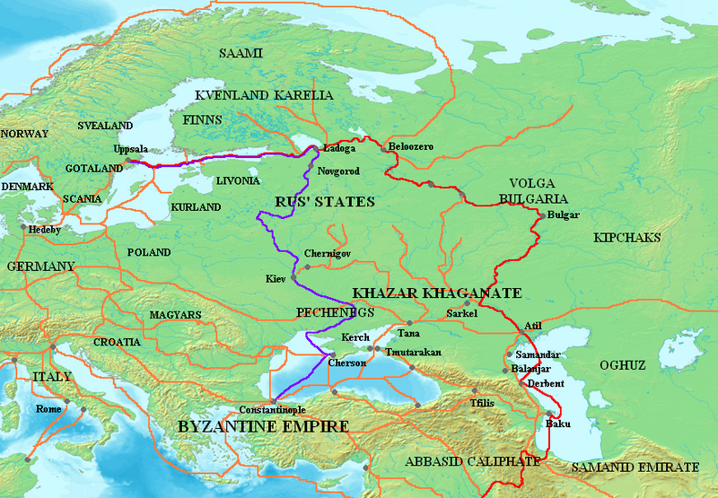
Беларуская (тарашкевіца): Мапа асноўных вараскіх гандлёвых шляхоў: Валжанскі (чырвоным) і шлях з варагаў у грэкі (філётавым). Аранжавым колерам паказаныя іншыя гандлёвыя шляхі VIII—XI стагодзьдзяў. Існуе дзьве вэрсіі крынічнай мапы: адна адпавядае вугорскай гістарыяграфіі, якая лічыць, што валахі зьніклі на тысячагадовы пэрыяд між 275 і 1300 рокамі; другая адпавядае румынскай гістарыяграфіі, якія гэтага не прымаюць.
Deutsch: Karte mit der wichtigsten Handelsrouten Waräger (Wolga-Handelsroute in Rot, de:Handelsroute von den Warägern zu den Griechen in Lila). Die anderen Straßen (8.–11. Jahrhundert) sind in Orange gehalten. Die Basiskarte existiert in zwei Versionen: eine im Einklang mit der ungarischen Geschichtsschreibung, die behauptet, dass die Sprecher der ostromanischen Sprachen für tausend Jahre zwischen 275 und 1300 verschwunden seien, eine andere im Einklang mit der rumänischen Geschichtsschreibung, die behauptet, dass sie nicht verschwunden seien.
English: Map showing the major Varangian trade routes, the Volga trade route (in red) and the Trade Route from the Varangians to the Greeks (in purple). Other trade routes of the 8th–11th centuries shown in orange. Background exist in two versions : one according with Hungarian historians who think that speakers of Eastern Romance languages vanished for a thousand years between 275 and 1300, another according with Romanian historians who think that they don't vanished.
Français : Carte montrant les principales routes commerciales varègues (Route commerciale de la Volga en rouge, Route commerciale des Varègues aux Grecs en violet). Les autres routes (8°-11° siècle) sont en orange. Le fond de carte existe en deux versions : l'une conforme à l'historiographie hongroise qui affirme que les locuteurs des langues romanes orientales ont disparu pendant mille ans entre 275 et 1300, une autre conforme à l'historiographie roumaine qui affirme qu'ils n'ont pas disparu.
Русский: Основные : (красный) и (фиолетовый). Оранжевым цветом показаны другие торговые пути VIII–XI веков. Базовая карта существует в двух версиях: одна соответствует венгерской историографии, в которой говорится, что Волохи исчезли на тысячу лет между 275 и 1300 годами, другая соответствует румынской историографии, которая утверждает, что они не исчезли. |
||||||||
| Fonte |
The following source corroborates the Volga route between the Gulf of Finland and Atil, although it gives a different Western route, over Smolensk:
|
||||||||
| Autor | Briangotts | ||||||||
| Permissão (Reutilizando este arquivo) |
Eu, titular dos direitos autorais desta obra, publico-a nos termos das seguintes licenças:
Você pode escolher a licença que desejar. |

|
Esta imagem de mapas (ou todas as imagens neste artigo ou categoria) deveriam ser recriadas usando gráficos vetoriais, como arquivos SVG. Isto tem várias vantagens; veja as imagens para rever para mais informações. Se já criou um arquivo SVG desta imagem, por favor, carregue-o. Depois do novo arquivo SVG ter sido carregado, substitua aqui esta predefinição pela predefinição
{{vector version available|nome da nova imagem.svg}}. |
Legendas
Adicione uma explicação em uma linha sobre o que este arquivo representa
Map of trade routes of 8th–11th centuries
Карта основних варязьких торгових шляхів, Волзького (червоним) і Торгового шляху з варяг у греки (фіолетового). Помаранчевим кольором показано інші торгові шляхи VIII–XI століть.
Itens retratados neste arquivo
retrata
image/png
Histórico do arquivo
Clique em uma data/horário para ver como o arquivo estava em um dado momento.
| Data e horário | Miniatura | Dimensões | Usuário | Comentário | |
|---|---|---|---|---|---|
| atual | 11h29min de 3 de outubro de 2023 |  | 872 × 605 (859 kB) | wikimediacommons>OrionNimrod | Restore original: "Wallachians" added by Romanian user, however it was no Wallachia in the 8-11th c: British historian, Martyn Rady - Nobility, land and service in medieval Hungary (p91–93): the sources before the 13th century do not contain references to Vlachs anywhere in Hungary and Transylvania or in Wallachia. Byzantine sources mentioned Vlachs all deep in the Balcan. Also map should make by academic historians not by personal POV. |
Uso do arquivo
As seguintes 2 páginas usa este arquivo:


 " class="attachment-atbs-s-4_3 size-atbs-s-4_3 wp-post-image" alt="O que estudar para o enem 2023">
 " class="attachment-atbs-s-4_3 size-atbs-s-4_3 wp-post-image" alt="Qual melhor curso para fazer em 2023">
 " class="attachment-atbs-s-4_3 size-atbs-s-4_3 wp-post-image" alt="Enem: Conteúdos E Aulas On-Line São Opção Para Os Estudantes">
 " class="attachment-atbs-s-4_3 size-atbs-s-4_3 wp-post-image" alt="Como Fazer Uma Carta De Apresentação">
 " class="attachment-atbs-s-4_3 size-atbs-s-4_3 wp-post-image" alt="Como Escrever Uma Boa Redação">
 " class="attachment-atbs-s-4_3 size-atbs-s-4_3 wp-post-image" alt="Concurso INSS edital 2022 publicado">


