Imagem numa resolução maior (3 027 × 2 010 pixels, tamanho: 543 kB, tipo MIME: image/jpeg)
|
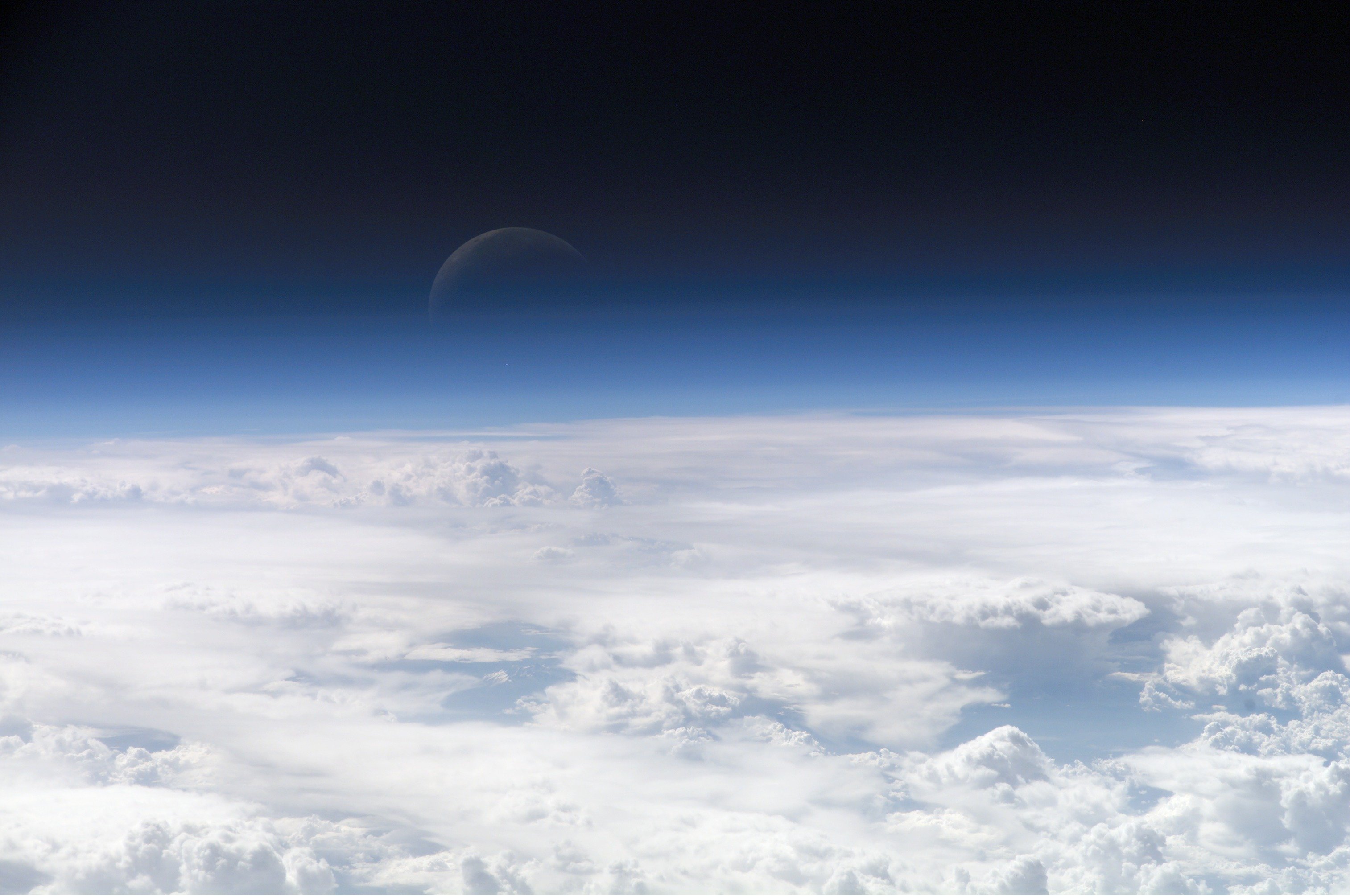
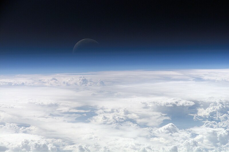
Esta imagem foi selecionada como a imagem do dia no Wikimedia Commons para 22 de fevereiro de 2013. Ela foi legendada da seguinte forma: English: View of the crescent moon through the top of the earth's atmosphere. Photographed from International Space Station by Expedition 13 crew over the South China Sea, just south of Macau. Outros idiomas:
Čeština: Pohled na srpek Měsíce skrz vršek zemské atmosféry. Vyfoceno posádkou Mezinárodní vesmírné stanice v rámci Expedice 13 nad Jihočínským mořem jižně od Macaa, 21,5° S, 113,3° V Deutsch: Die oberen Schichten der Erdatmosphäre, gesehen von der Internationalen Raumstation (ISS) während der ISS-Expedition 13 English: View of the crescent moon through the top of the earth's atmosphere. Photographed from International Space Station by Expedition 13 crew over the South China Sea, just south of Macau. Italiano: Vista della luna crescente dalla sommità dell'atmosfera terrestre. Foto scattata alle coordinate 21.5°N, 113.3°E dall'equipaggio della Stazione Spaziale Orbitante Internazionale Expedition 13 sopra il Mar Cinese Orientale, appena a sud di Macau (NASA image ID: ISS013-E-54329). Magyar: Félholdra táruló kilátás a Föld légkörén keresztül. A fénykép a Nemzetközi Űrállomás 13-dik expedícióján, a Dél-kínai-tenger fölött, Makaótól délre készült. Nederlands: Zicht op de maansikkel door de bovenkant van de atmosfeer van de aarde. Gefotografeerd boven 21,5° N, 113,3° E door de bemanning van het internationaal ruimtestation ISS tijdens expeditie 13 boven de Zuid-Chinese Zee, net ten zuiden van Macau. Polski: Widok Księżyca z górnych warstw amosfery ziemskiej. Fotografia wykonana przez załogę Ekspedycji 13 Międzynarodowej Stacji Kosmicznej nad Morzem Południowochińskim, na południe od Makau Svenska: En månskära sedd genom atmosfärens övre lager, fotograferad från Internationella rymdstationen ovanför Sydkinesiska sjön söder om Macau. ქართული: სამხრეთი ჩინეთის ზღვის თავზე, მაკაოს სამხრეთით, მე-13 ექსპედიციის მონაწილის მიერ გადაღებული ნახევარმთვარის ფოტო დედამიწის ატმოსფეროს ზედა ფენებიდან. 中文: 地球大气层上的新月,地理位置为中国南海上空,经纬度21.5°N, 113.3°E,由国际空间站第13远征组成员拍摄。 |
Descrição do arquivo
| Descrição |
Čeština: Pohled na srpek Měsíce skrz vršek zemské atmosféry. Vyfoceno posádkou Mezinárodní vesmírné stanice v rámci Expedice 13 nad Jihočínským mořem jižně od Macaa, 21,5° S, 113,3° V
English: View of the crescent moon through the top of the Earth's atmosphere. Photographed above 21.5°N, 113.3°E by International Space Station crew Expedition 13 over the South China Sea, just south of Macau (NASA image ID: ISS013-E-54329).
Français : Photo des couches hautes de l'atmosphère terrestre, prise par 21.5°N, 113.3°E par la Station spatiale internationale au cours de l'Expédition 13 au-dessus de la Mer de Chine méridionale, juste au sud de Macao. Numéro d'identification d'image de la NASA : ISS013-E-54329.
Italiano: Vista della luna crescente dalla sommità dell'atmosfera terrestre. Foto scattata alle coordinate 21.5°N, 113.3°E dall'equipaggio della Stazione Spaziale Internazionale Expedition 13 sopra il Mar Cinese Orientale, appena a sud di Macau (NASA image ID: ISS013-E-54329).
ქართული: სამხრეთი ჩინეთის ზღვის თავზე, მაკაოს სამხრეთით, მე-13 ექსპედიციის მონაწილის მიერ გადაღებული ნახევარმთვარის ფოტო დედამიწის ატმოსფეროს ზედა ფენებიდან.
Polski: Zdjęcie górnych warstw atmosfery ziemskiej z widocznym przejściem w przestrzeń kosmiczną.
Ελληνικά: Η Γήινη ατμόσφαιρα, η φωτογραφία ελήφθη από το διάστημα κι ύψος 335 χιλιόμετρα |
| Data | |
| Fonte | http://eol.jsc.nasa.gov/scripts/sseop/photo.pl?mission=ISS013&roll=E&frame=54329 |
| Autor | NASA Earth Observatory |
Este(a) imagem ou vídeo foi catalogado(a) por um dos centros dos Estados Unidos da América para a Administração Nacional da Aeronáutica e do Espaço (NASA), sobre o código ID: ISS013-E-54329. Esta marcação não indica o estado dos direitos de autor da obra aqui mostrada. Continua a ser necessária uma marcação normal de direitos de autor. Veja Commons:Licenciamento para mais informações. Outras línguas:
|
Licenciamento
| Esta obra encontra-se no domínio público porque foi criada pela NASA. A política de direitos autorais da NASA diz que "o material da NASA não é protegido por direitos autorais a não ser quando especificado". (página sobre direitos autorais da NASA ou Política de uso de imagens da JPL). | ||
 |
Avisos:
|
Image information
Identification
Top Of The Atmosphere
Mission: ISS013 Roll: E Frame: 54329 Mission ID on the Film or image: ISS013
Country or Geographic Name:
Features: EARTH LIMB, MOON, CLOUD TOPS
Center Point Latitude: Center Point Longitude: (Negative numbers indicate south for latitude and west for longitude)
Stereo: (Yes indicates there is an adjacent picture of the same area)
ONC Map ID: JNC Map ID:
'MORALES'
Camera Tilt: Low Oblique
Camera Focal Length: 400mm
Camera: E4: Kodak DCS760C Electronic Still Camera
Film: 3060E : 3060 x 2036 pixel CCD, RGBG array.
Quality
Film Exposure:
Percentage of Cloud Cover: 100 (76-100)
Nadir
Date: 20060720 (YYYYMMDD)GMT Time: 082858 (HHMMSS)
Nadir Point Latitude: 21.5, Longitude: 113.3 (Negative numbers indicate south for latitude and west for longitude)
Nadir to Photo Center Direction:
Sun Azimuth: 281 (Clockwise angle in degrees from north to the sun measured at the nadir point)
Spacecraft Altitude: 181 nautical miles (335 km)
Sun Elevation Angle: 35 (Angle in degrees between the horizon and the sun, measured at the nadir point)
Orbit Number: 3839
Histórico do arquivo
Clique em uma data/horário para ver como o arquivo estava em um dado momento.
| Data e horário | Miniatura | Dimensões | Usuário | Comentário | |
|---|---|---|---|---|---|
| atual | 08h09min de 27 de fevereiro de 2007 | | 3 027 × 2 010 (543 kB) | wikimediacommons>SirGrant | {{Information |Description= Image of the top layers of the earth's atmosphere leading to space |Source= [http://eobadmin.gsfc.nasa.gov/Newsroom/NewImages/images.php3?img_id=17542] direct link:[http://eobadmin.gsfc.nasa.gov/Newsroom/NewImages/Images/ISS01 |
Uso do arquivo
As seguintes 5 páginas usa este arquivo:
 " class="attachment-atbs-s-4_3 size-atbs-s-4_3 wp-post-image" alt="O que estudar para o enem 2023">
 " class="attachment-atbs-s-4_3 size-atbs-s-4_3 wp-post-image" alt="Qual melhor curso para fazer em 2023">
 " class="attachment-atbs-s-4_3 size-atbs-s-4_3 wp-post-image" alt="Enem: Conteúdos E Aulas On-Line São Opção Para Os Estudantes">
 " class="attachment-atbs-s-4_3 size-atbs-s-4_3 wp-post-image" alt="Como Fazer Uma Carta De Apresentação">
 " class="attachment-atbs-s-4_3 size-atbs-s-4_3 wp-post-image" alt="Como Escrever Uma Boa Redação">
 " class="attachment-atbs-s-4_3 size-atbs-s-4_3 wp-post-image" alt="Concurso INSS edital 2022 publicado">


