
Tamanho desta previsualização: 800 × 566 pixels. Outras resoluções: 320 × 226 pixels | 640 × 453 pixels | 1 024 × 725 pixels | 1 280 × 906 pixels | 1 765 × 1 249 pixels.
Imagem numa resolução maior (1 765 × 1 249 pixels, tamanho: 124 kB, tipo MIME: image/png)

|
Esta imagem de mapas (ou todas as imagens neste artigo ou categoria) deveriam ser recriadas usando gráficos vetoriais, como arquivos SVG. Isto tem várias vantagens; veja as imagens para rever para mais informações. Se já criou um arquivo SVG desta imagem, por favor, carregue-o. Depois do novo arquivo SVG ter sido carregado, substitua aqui esta predefinição pela predefinição
{{vector version available|nome da nova imagem.svg}}. |
| Descrição |
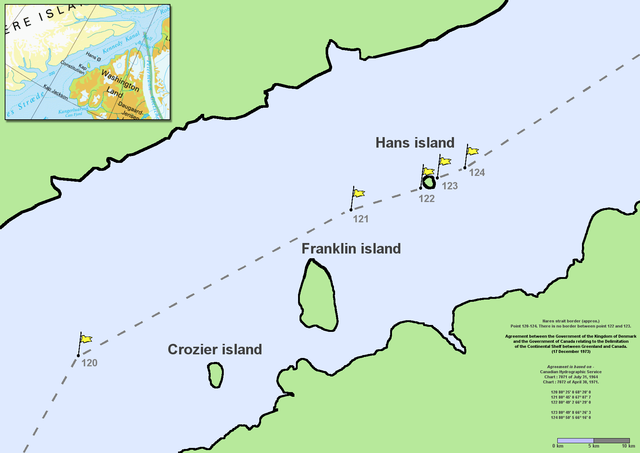
en:Nares Strait (en:Kennedy Channel) border (approx.) Point 120–124. There is no border between point 122 and 123. Agreement between the Government of the Kingdom of Denmark and the Government of Canada relating to the Delimitation of the Continental Shelf between Greenland and Canada. (17 December 1973) Agreement is based on en:Canadian Hydrographic Service charts 7071 of July 31, 1964 and 7072 of April 30, 1971
|
| Data | Commons upload by File Upload Bot (Magnus Manske) 10:54, 7 June 2006 (UTC) |
| Fonte |
A utilização deste arquivo é regulada nos termos da licença Creative Commons Atribuição 2.5 Genérica.
|
| Autor | User Twthmoses on en.wikipedia |
Originally from en.wikipedia; description page is (was) here
- 06:02, 29 July 2005 Twthmoses 1765x1249 (196,934 bytes) ([[:en:Nares strait]] border (approx.) Point 120-124. There is no border between point 122 and 123. ''Agreement between the Government of the Kingdom of Denmark and the Government of Canada relating to the Delimitation of the Continental Shelf between Greenla)
Histórico do arquivo
Clique em uma data/horário para ver como o arquivo estava em um dado momento.
| Data e horário | Miniatura | Dimensões | Usuário | Comentário | |
|---|---|---|---|---|---|
| atual | 10h32min de 24 de março de 2015 | | 1 765 × 1 249 (124 kB) | wikimediacommons>RokerHRO | optipng -o7 -i0 → 35.36% decrease |
Uso do arquivo
As seguinte página usa este arquivo:
 " class="attachment-atbs-s-4_3 size-atbs-s-4_3 wp-post-image" alt="O que estudar para o enem 2023">
 " class="attachment-atbs-s-4_3 size-atbs-s-4_3 wp-post-image" alt="Qual melhor curso para fazer em 2023">
 " class="attachment-atbs-s-4_3 size-atbs-s-4_3 wp-post-image" alt="Enem: Conteúdos E Aulas On-Line São Opção Para Os Estudantes">
 " class="attachment-atbs-s-4_3 size-atbs-s-4_3 wp-post-image" alt="Como Fazer Uma Carta De Apresentação">
 " class="attachment-atbs-s-4_3 size-atbs-s-4_3 wp-post-image" alt="Como Escrever Uma Boa Redação">
 " class="attachment-atbs-s-4_3 size-atbs-s-4_3 wp-post-image" alt="Concurso INSS edital 2022 publicado">


.png)
.png)