
Sem resolução maior disponível.
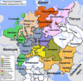
Map_of_the_Imperial_Circles_(1512)-en.png (610 × 599 pixels, tamanho: 321 kB, tipo MIME: image/png)
Descrição do arquivo
en:User:Silverhelm is the author of this image file.
Its contents are based in part on a map published in the "Historical Atlas" by Prof. William R Shepherd, pub. Henry Holt & Co. (New York, 1911).
Other versions:
[]
1512
-
 български (PNG)
 -
 Deutsch (PNG)
 -
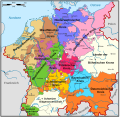
 English (PNG)
 -
 français
 -
 magyar (PNG)
-bg.png)
-de.png)
-en.png)
-fr.svg)
.png)
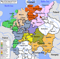
1560
-
 Deutsch
 -
 English (original)
 -
 español
 -
 Latina
 -
 Nederlands
-de.svg)
-en.svg)
-es.svg)
-la.svg)
-nl.svg)
derivative works
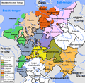
Obras derivadas deste arquivo: Map of the Imperial Circles (1512)-bg.png
Licenciamento
A utilização deste arquivo é regulada nos termos da licença Creative Commons Atribuição-Partilha nos Termos da Mesma Licença 2.5 Genérica.
- Você é livre:
- para compartilhar – copiar, distribuir e transmitir a obra
- para remixar – para adaptar o trabalho
- Sob as seguintes condições:
- atribuição – Você deve dar crédito apropriado, fornecer um link para a licença e indicar se as alterações foram feitas. Você pode fazê-lo de qualquer maneira razoável, mas não de maneira alguma que sugira que o licenciador endossa você ou seu uso.
- compartilhar igualmente – Se você remixar, transformar ou construir sobre o material, você deve distribuir suas contribuições sob a licença igual ou compatível como o original.
Histórico do arquivo
Clique em uma data/horário para ver como o arquivo estava em um dado momento.
| Data e horário | Miniatura | Dimensões | Usuário | Comentário | |
|---|---|---|---|---|---|
| atual | 01h39min de 17 de junho de 2006 | | 610 × 599 (321 kB) | wikimediacommons>~Pyb | en:User:Silverhelm is the author of this image file. Its contents are based in part on a map published in the "Historical Atlas" by Prof. William R Shepherd, pub. Henry Holt & Co. (New York, 1911). Category:Maps of the Holy Roman Empire |
Uso do arquivo
As seguinte página usa este arquivo:
 " class="attachment-atbs-s-4_3 size-atbs-s-4_3 wp-post-image" alt="O que estudar para o enem 2023">
 " class="attachment-atbs-s-4_3 size-atbs-s-4_3 wp-post-image" alt="Qual melhor curso para fazer em 2023">
 " class="attachment-atbs-s-4_3 size-atbs-s-4_3 wp-post-image" alt="Enem: Conteúdos E Aulas On-Line São Opção Para Os Estudantes">
 " class="attachment-atbs-s-4_3 size-atbs-s-4_3 wp-post-image" alt="Como Fazer Uma Carta De Apresentação">
 " class="attachment-atbs-s-4_3 size-atbs-s-4_3 wp-post-image" alt="Como Escrever Uma Boa Redação">
 " class="attachment-atbs-s-4_3 size-atbs-s-4_3 wp-post-image" alt="Concurso INSS edital 2022 publicado">


-en.png)