
Tamanho desta visualização em PNG deste arquivo em SVG: 512 × 386 pixels. Outras resoluções: 319 × 240 pixels | 637 × 480 pixels | 1 019 × 768 pixels | 1 280 × 965 pixels | 2 560 × 1 930 pixels.
Imagem numa resolução maior (arquivo SVG, de 512 × 386 pixels, tamanho: 468 kB)
Descrição do arquivo
| Descrição |
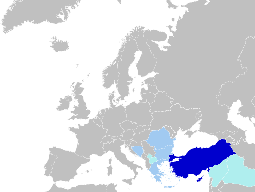
English: Status of Turkish Language.
Countries where it is recognized as a minority language and co-official in at least one municipality in Macedonia, Republic of Kosovo and Iraq.
Türkçe: Türkçenin Statüsü.
Azınlık dil olarak tanınan ve en az bir belediyede resmî dil olarak kabul eden ülkeler: Makedonya, Kosova Cumhuriyeti ve Irak.
Bahasa Indonesia: Status bahasa Turki.
Negara yang mengakui sebagai bahasa minoritas dan salah satu bahasa resmi di setidaknya satu munisipalitas Makedonia, Republik Kosovo dan Irak. |
| Data | |
| Fonte | Trabalho próprio pelo carregador, blank map: File:Blank map of Europe (without disputed regions).svg by User:Nordwestern |
| Autor | Jelican9 |
Licenciamento
Eu, titular dos direitos autorais desta obra, publico-a nos termos da seguinte licença:
| Este arquivo esta disponível nos termos Creative Commons CC0 1.0 Universal Public Domain Dedication. | |
| A pessoa que associou uma obra a este documento dedicou a obra ao domínio público, renunciando todos os seus direitos sobre a obra em todo o mundo ao abrigo da legislação de direitos autorais, e todos os direitos legais conexos que tinha sobre a obra, na medida permitida por lei. Obras disponibilizadas nos termos CC0 não requerem atribuição. Ao citar a obra, não deve sugerir aprovação por parte do autor.
|
Histórico do arquivo
Clique em uma data/horário para ver como o arquivo estava em um dado momento.
| Data e horário | Miniatura | Dimensões | Usuário | Comentário | |
|---|---|---|---|---|---|
| atual | 14h34min de 15 de abril de 2024 | | 512 × 386 (468 kB) | wikimediacommons>Lionel Cristiano | Update |
Uso do arquivo
As seguintes 2 páginas usa este arquivo:
 " class="attachment-atbs-s-4_3 size-atbs-s-4_3 wp-post-image" alt="O que estudar para o enem 2023">
 " class="attachment-atbs-s-4_3 size-atbs-s-4_3 wp-post-image" alt="Qual melhor curso para fazer em 2023">
 " class="attachment-atbs-s-4_3 size-atbs-s-4_3 wp-post-image" alt="Enem: Conteúdos E Aulas On-Line São Opção Para Os Estudantes">
 " class="attachment-atbs-s-4_3 size-atbs-s-4_3 wp-post-image" alt="Como Fazer Uma Carta De Apresentação">
 " class="attachment-atbs-s-4_3 size-atbs-s-4_3 wp-post-image" alt="Como Escrever Uma Boa Redação">
 " class="attachment-atbs-s-4_3 size-atbs-s-4_3 wp-post-image" alt="Concurso INSS edital 2022 publicado">


.svg)