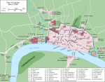
London_1300_Historical_Atlas_William_R_Shepherd_(died_1934).PNG (700 × 536 pixels, tamanho: 644 kB, tipo MIME: image/png)
Este arquivo é do Wikimedia Commons e pode ser utilizado por outros projetos. Sua página de descrição de arquivo é reproduzida abaixo.

|
Este ficheiro foi suplantado por File:Plan of London in 1300.jpg. Recomenda-se que o outro ficheiro seja utilizado. Nota: Este ficheiro não será apagado, até que seja explicitamente designado para apagar.
|

|

|
File:Map of London, 1300.svg é uma versão vetorial desta imagem. Ela deve ser usada no lugar desta imagem rasterizada, se não for de qualidade inferior.
File:London 1300 Historical Atlas William R Shepherd (died 1934).PNG → File:Map of London, 1300.svg
Para mais informações, consulte Ajuda:SVG.
|
Source: en:Image:London 1300 Historical Atlas William R Shepherd (died 1934).PNG, 03:43, 14 May 2005 . . CalJW (Talk) . . 700x536 (659,361 bytes) (A map of London in 1300 from a historical atlas by William R Shepherd. Apart from religious foundations and two or three other complexes, the city is confined within its walls, which are well inside the present boundary of the City of London. The City)
| Public domainPublic domainfalsefalse |
|
Este material é de domínio público nos países onde os direitos autorais se estendem por 70 anos (ou menos) após a morte de seu autor. Observe que alguns países tem prazos de direitos autorais superiores a 70 anos: o México tem 100 anos, a Jamaica tem 95 anos, a Colômbia tem 80 anos e a Guatemala e Samoa têm 75 anos. Esta imagem pode não estar em domínio público nestes países, que aliás não implementam a regra do prazo mais curto. Os diretos autorais podem se estender a trabalhos criados por franceses que morreram pela França na Segunda Guerra Mundial (mais informações), russos que serviram na Frente Oriental da Segunda Guerra Mundial (conhecida como a Grande Guerra Patriótica na Rússia) e vítimas postumamente reabilitadas da repressão soviética (mais informações).
| |
| Este arquivo foi identificado como livre de restrições conhecidas específicas a direitos autorais, incluindo todos os direitos conexos. | |
https://creativecommons.org/publicdomain/mark/1.0/PDMCreative Commons Public Domain Mark 1.0falsefalse
Legendas
Itens retratados neste arquivo
retrata
image/png
Histórico do arquivo
Clique em uma data/horário para ver como o arquivo estava em um dado momento.
| Data e horário | Miniatura | Dimensões | Usuário | Comentário | |
|---|---|---|---|---|---|
| atual | 18h20min de 20 de maio de 2006 |  | 700 × 536 (644 kB) | wikimediacommons>Siebrand | Higher resolution from source |
Uso do arquivo
Não há páginas que usem este arquivo.
Metadados
Este ficheiro contém informação adicional, provavelmente adicionada a partir da câmara digital ou scanner utilizada para criar ou digitalizar a imagem. Caso o ficheiro tenha sido modificado a partir do seu estado original, alguns detalhes poderão não refletir completamente as mudanças efetuadas.
| Comentário de arquivo PNG |
|
|---|


 " class="attachment-atbs-s-4_3 size-atbs-s-4_3 wp-post-image" alt="O que estudar para o enem 2023">
 " class="attachment-atbs-s-4_3 size-atbs-s-4_3 wp-post-image" alt="Qual melhor curso para fazer em 2023">
 " class="attachment-atbs-s-4_3 size-atbs-s-4_3 wp-post-image" alt="Enem: Conteúdos E Aulas On-Line São Opção Para Os Estudantes">
 " class="attachment-atbs-s-4_3 size-atbs-s-4_3 wp-post-image" alt="Como Fazer Uma Carta De Apresentação">
 " class="attachment-atbs-s-4_3 size-atbs-s-4_3 wp-post-image" alt="Como Escrever Uma Boa Redação">
 " class="attachment-atbs-s-4_3 size-atbs-s-4_3 wp-post-image" alt="Concurso INSS edital 2022 publicado">


