
Tamanho desta visualização em PNG deste arquivo em SVG: 756 × 599 pixels. Outras resoluções: 303 × 240 pixels | 606 × 480 pixels | 969 × 768 pixels | 1 280 × 1 015 pixels | 2 560 × 2 030 pixels | 2 283 × 1 810 pixels.
Imagem numa resolução maior (arquivo SVG, de 2 283 × 1 810 pixels, tamanho: 3,07 MB)
Descrição do arquivo
| Descrição |
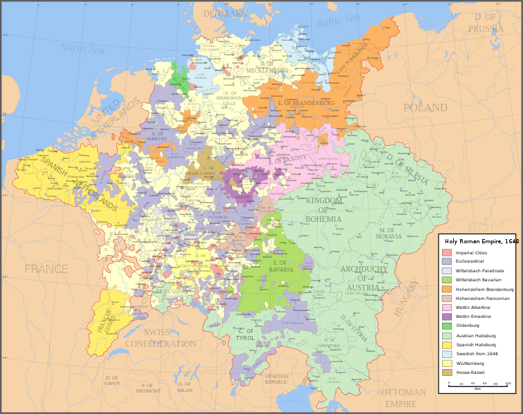
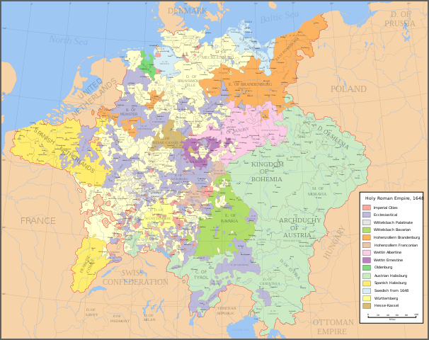
English: Map of the Holy Roman Empire in 1648, after the Peace of Westphalia which ended the Thirty Years' War. Deutsch: Karte des Heiligen Römischen Reiches 1648, nach dem Westfälischer Friede, der den Dreißigjähriger Krieg beendete. Français : Carte du Saint-Empire à 1648, après la paix de Westphalie qui mettent fin à la guerre de Trente Ans. Version française est disponible à File:Holy Roman Empire 1648 fr.svg. Српски / srpski: Мапа Светог римског царства у 1648, након Вестфалског мира којим је завршен Тридесетогодишњи рат.
|
English | Deutsch | Français | Српски |
||
|---|---|---|---|---|---|
| A | Archbishopric | Erzbistum | Archevêché | АДИЈ. | Архидијецеза |
| B | Bishopric | Bistum | Évêché | ДИЈ. | Дијецеза |
| C | County | Grafschaft | Comté | ОКР./ГРОФ. | Округ/грофовија |
| D | Duchy | Herzogtum | Duché | ВОЈВ. | Војводство |
| E | Electorate | Kurfürstentum | Électorat | ЕЛЕКТ. | Електорат |
| L | Landgraviate | Landgrafschaft | Landgraviat | ЛГРОФ. | Ландгрофовија |
| M | Margraviate | Markgrafschaft | Margraviat | МГРОФ. | Маркгрофовија |
| P | Principality | Fürstentum | Principauté | ГРОФ./ОКР. | Грофовија/округ |
Legend / Farblegende / Légende / Легенда
English | Deutsch | Français | Српски |
|
|---|---|---|---|---|
Palatinat des Wittelsbach |
||||
Wittelsbach Bavaria |
Wittelsbacher Bayern |
Bavière des Wittelsbach |
Вителсбах, баварски | |
Hohenzollern Franconia |
Hohenzollerner Franken |
Хоенцолерн, франконски | ||
Wettin Ernestine Saxony |
Wettiner Ernestiner Sachsen |
Saxe de la branche ernestine des Wettin |
Ветин, ернестински | |
Made from the public domain map "Central Europe about 1648" from the Historical Atlas by William R. Shepherd, at the Perry-Castañeda Library Map Collection at the University of Texas. Further information from Overy, Richard, 2006, The Times Complete history of the world Times Books ISBN 0007181299, and from this map
See also other maps at external links:
- Central Europe 1648
- Map on personal site, Europe in 1648
- Treaty of Westphalia
- 1648 map of Prussia
- Britannica, Spanish domains in 1648
Este(a) desenho vetorial não especificado foi criado com Inkscape .
(Reutilizando este arquivo)

|
É concedida permissão para copiar, distribuir e/ou modificar este documento nos termos da Licença de Documentação Livre GNU, versão 1.2 ou qualquer versão posterior publicada pela Free Software Foundation; sem Seções Invariantes, sem textos de Capa e sem textos de Contra-Capa. É incluída uma cópia da licença na seção intitulada GNU Free Documentation License. |
| A utilização deste arquivo é regulada nos termos da licença Creative Commons Atribuição-Partilha nos Termos da Mesma Licença 3.0 Unported. | ||
| ||
| Esta marca de licenciamento foi adicionada a este arquivo durante a atualização da licença GFDL. |
[]
-
 inglês SVG
 -
 espanhol SVG
 -
 francês SVG
 -
 georgiano SVG
 -
 sérvio SVG
 -
 English: Blank PNG
 -
 inglês PNG
 -
 espanhol PNG
 -
 sérvio PNG
 -
 russo PNG


|
This SVG file contains embedded text that can be translated into your language, using any capable SVG editor, text editor or the SVG Translate tool. For more information see: About translating SVG files. |
Histórico do arquivo
Clique em uma data/horário para ver como o arquivo estava em um dado momento.
| Data e horário | Miniatura | Dimensões | Usuário | Comentário | |
|---|---|---|---|---|---|
| atual | 20h43min de 24 de julho de 2022 | | 2 283 × 1 810 (3,07 MB) | wikimediacommons>Maproom | ZWEIBRCKEN -> ZWEIBRÜCKEN, Treves -> Trier, Liege -> Liège |
Uso do arquivo
As seguintes 3 páginas usa este arquivo:
 " class="attachment-atbs-s-4_3 size-atbs-s-4_3 wp-post-image" alt="O que estudar para o enem 2023">
 " class="attachment-atbs-s-4_3 size-atbs-s-4_3 wp-post-image" alt="Qual melhor curso para fazer em 2023">
 " class="attachment-atbs-s-4_3 size-atbs-s-4_3 wp-post-image" alt="Enem: Conteúdos E Aulas On-Line São Opção Para Os Estudantes">
 " class="attachment-atbs-s-4_3 size-atbs-s-4_3 wp-post-image" alt="Como Fazer Uma Carta De Apresentação">
 " class="attachment-atbs-s-4_3 size-atbs-s-4_3 wp-post-image" alt="Como Escrever Uma Boa Redação">
 " class="attachment-atbs-s-4_3 size-atbs-s-4_3 wp-post-image" alt="Concurso INSS edital 2022 publicado">


