
Tamanho desta previsualização: 800 × 559 pixels. Outras resoluções: 320 × 224 pixels | 640 × 447 pixels | 940 × 657 pixels.
Imagem numa resolução maior (940 × 657 pixels, tamanho: 978 kB, tipo MIME: image/png)
Descrição do arquivo
| Descrição |
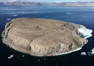
English: Hans Island / Hans Ø as seen from the air, looking toward the west with Ellesmere Island in the background. The international border runs approximately from the top left to the lower right, with Denmark on the left and Canada on the right. |
| Data | |
| Fonte | Trabalho próprio pelo carregador |
| Autor | Toubletap |
| Localização da câmara | | Esta e outras imagens nas suas localizações em: OpenStreetMap |
|---|
Licenciamento
Eu, titular dos direitos autorais desta obra, publico-a nos termos das seguintes licenças:
A utilização deste arquivo é regulada nos termos da licença Creative Commons Atribuição-Partilha nos Termos da Mesma Licença 3.0 Unported.
- Você é livre:
- para compartilhar – copiar, distribuir e transmitir a obra
- para remixar – para adaptar o trabalho
- Sob as seguintes condições:
- atribuição – Você deve dar crédito apropriado, fornecer um link para a licença e indicar se as alterações foram feitas. Você pode fazê-lo de qualquer maneira razoável, mas não de maneira alguma que sugira que o licenciador endossa você ou seu uso.
- compartilhar igualmente – Se você remixar, transformar ou construir sobre o material, você deve distribuir suas contribuições sob a licença igual ou compatível como o original.

|
É concedida permissão para copiar, distribuir e/ou modificar este documento nos termos da Licença de Documentação Livre GNU, versão 1.2 ou qualquer versão posterior publicada pela Free Software Foundation; sem Seções Invariantes, sem textos de Capa e sem textos de Contra-Capa. É incluída uma cópia da licença na seção intitulada GNU Free Documentation License. |
Você pode escolher a licença que desejar.
| Annotations | This image is annotated: View the annotations at Commons |
Histórico do arquivo
Clique em uma data/horário para ver como o arquivo estava em um dado momento.
| Data e horário | Miniatura | Dimensões | Usuário | Comentário | |
|---|---|---|---|---|---|
| atual | 16h20min de 16 de agosto de 2012 | | 940 × 657 (978 kB) | wikimediacommons>Toubletap | {{Information |Description ={{en|1=Hans Island as seen from the air, with Ellesmere Island in the background.}} |Source ={{own}} |Author =Toubletap |Date =2012-08-15 |Permission = |other_versions = }}... |
Uso do arquivo
As seguinte página usa este arquivo:
 " class="attachment-atbs-s-4_3 size-atbs-s-4_3 wp-post-image" alt="O que estudar para o enem 2023">
 " class="attachment-atbs-s-4_3 size-atbs-s-4_3 wp-post-image" alt="Qual melhor curso para fazer em 2023">
 " class="attachment-atbs-s-4_3 size-atbs-s-4_3 wp-post-image" alt="Enem: Conteúdos E Aulas On-Line São Opção Para Os Estudantes">
 " class="attachment-atbs-s-4_3 size-atbs-s-4_3 wp-post-image" alt="Como Fazer Uma Carta De Apresentação">
 " class="attachment-atbs-s-4_3 size-atbs-s-4_3 wp-post-image" alt="Como Escrever Uma Boa Redação">
 " class="attachment-atbs-s-4_3 size-atbs-s-4_3 wp-post-image" alt="Concurso INSS edital 2022 publicado">


