Sem resolução maior disponível.
Golan_Heights_Map.PNG (415 × 354 pixels, tamanho: 19 kB, tipo MIME: image/png)

|
Esta imagem de locator map (ou todas as imagens neste artigo ou categoria) deveriam ser recriadas usando gráficos vetoriais, como arquivos SVG. Isto tem várias vantagens; veja as imagens para rever para mais informações. Se já criou um arquivo SVG desta imagem, por favor, carregue-o. Depois do novo arquivo SVG ter sido carregado, substitua aqui esta predefinição pela predefinição
{{vector version available|nome da nova imagem.svg}}. |
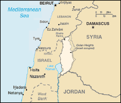
A map of the Golan Heights, made entirely of info from the CIA World Factbook. If this is even elligible for copyright, I hereby release it into the public domain.
Esta imagem se encontra no domínio público, já que seu conteúdo provém de CIA World Factbook, um trabalho da Agência Central de Inteligência dos Estados Unidos da América.
|
 |
Histórico do arquivo
Clique em uma data/horário para ver como o arquivo estava em um dado momento.
| Data e horário | Miniatura | Dimensões | Usuário | Comentário | |
|---|---|---|---|---|---|
| atual | 20h58min de 28 de junho de 2005 | | 415 × 354 (19 kB) | wikimediacommons>Quadell | A map of the Golan Heights, made entirely of info from the CIA World Factbook. If this is even elligible for copyright, I hereby release it into the public domain. {{PD-USGov-CIA-WF}} Category:Maps of Israel Category:Maps of Syria |
Uso do arquivo
As seguinte página usa este arquivo:
 " class="attachment-atbs-s-4_3 size-atbs-s-4_3 wp-post-image" alt="O que estudar para o enem 2023">
 " class="attachment-atbs-s-4_3 size-atbs-s-4_3 wp-post-image" alt="Qual melhor curso para fazer em 2023">
 " class="attachment-atbs-s-4_3 size-atbs-s-4_3 wp-post-image" alt="Enem: Conteúdos E Aulas On-Line São Opção Para Os Estudantes">
 " class="attachment-atbs-s-4_3 size-atbs-s-4_3 wp-post-image" alt="Como Fazer Uma Carta De Apresentação">
 " class="attachment-atbs-s-4_3 size-atbs-s-4_3 wp-post-image" alt="Como Escrever Uma Boa Redação">
 " class="attachment-atbs-s-4_3 size-atbs-s-4_3 wp-post-image" alt="Concurso INSS edital 2022 publicado">


