Tamanho desta previsualização: 800 × 364 pixels. Outras resoluções: 320 × 146 pixels | 928 × 422 pixels.
Imagem numa resolução maior (928 × 422 pixels, tamanho: 23 kB, tipo MIME: image/png)
Descrição do arquivo
| Descrição |
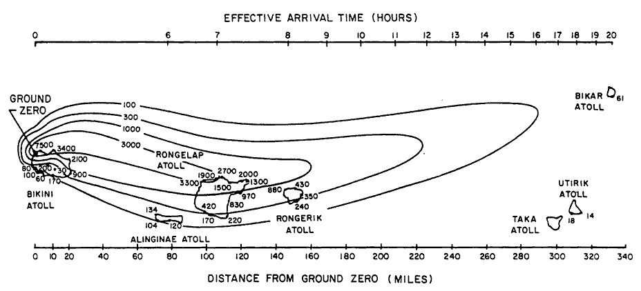
English: Path of nuclear fallout plume after U.S. nuclear weapons test Bravo (yield 15 Mt) on Bikini Atoll. It is the single worst contamination accident in U.S. nuclear history. The test was part of the Operation Castle. The Bravo event was an experimental thermonuclear device surface event. The numbers correspond with estimated total (accumulated) dose contours (rad).
Suomi: Ydinkoe Bravon (räjähdysvoima 15 Mt) radioaktiivinen laskeuma. Bravo testi on Yhdysvaltojen pahin ydinonnettomuus. Testi oli osa Operaatio Castlea. Bravo räjäytys oli kokeellinen fuusioreaktioon perustuva pintaräjäytys Bikinin atollilla. Kuvan numerot kuvaavat arvioituja kertyneen kokonaislaskeuman rajoja (rad). |
| Data | |
| Fonte | Samuel Glasstone and Phillip J. Dolan, eds., The Effects of Nuclear Weapons, 3rd. edn. (Washington, D.C.: DOD and DOE, 1977): 437. [Gamma doses are Roentgens from arrival time to 96 hours (4 days) after detonation, outside on land. Glasstone and Dolan mention that because data from the ocean was not obtained in this particular test, Bravo, the fallout contours to the north of the islands are uncertain and some other fallout patterns for the same test ascribe the high levels measured on Rongelap to a "hotspot" of the sort measured in the ocean downwind in later tests. |
| Autor | United States Department of Energy |
| Outras versões |
 |

|
Esta imagem de gráficos (ou todas as imagens neste artigo ou categoria) deveriam ser recriadas usando gráficos vetoriais, como arquivos SVG. Isto tem várias vantagens; veja as imagens para rever para mais informações. Se já criou um arquivo SVG desta imagem, por favor, carregue-o. Depois do novo arquivo SVG ter sido carregado, substitua aqui esta predefinição pela predefinição
{{vector version available|nome da nova imagem.svg}}. |
Licenciamento
| This image is a work of a United States Department of Energy (or predecessor organization) employee, taken or made as part of that person's official duties. As a work of the U.S. federal government, the image is in the public domain.
Please note that national laboratories operate under varying licences and some are not free. Check the site policies of any national lab before crediting it with this tag.
|

|
Histórico do arquivo
Clique em uma data/horário para ver como o arquivo estava em um dado momento.
| Data e horário | Miniatura | Dimensões | Usuário | Comentário | |
|---|---|---|---|---|---|
| atual | 17h25min de 10 de dezembro de 2005 | | 928 × 422 (23 kB) | wikimediacommons>Fastfission~commonswiki | Image of nuclear fallout dispersal from the Castle Bravo nuclear test, 28 Feb 1954. ==Licensing== *Source: Samuel Glasstone and Phillip J. Dolan, eds., ''The Effects of Nuclear Weapons'', 3rd. edn. (Washington, D.C.: DOD and DOE, 1977): 437. {{PD-USG |
Uso do arquivo
As seguintes 2 páginas usa este arquivo:
 " class="attachment-atbs-s-4_3 size-atbs-s-4_3 wp-post-image" alt="O que estudar para o enem 2023">
 " class="attachment-atbs-s-4_3 size-atbs-s-4_3 wp-post-image" alt="Qual melhor curso para fazer em 2023">
 " class="attachment-atbs-s-4_3 size-atbs-s-4_3 wp-post-image" alt="Enem: Conteúdos E Aulas On-Line São Opção Para Os Estudantes">
 " class="attachment-atbs-s-4_3 size-atbs-s-4_3 wp-post-image" alt="Como Fazer Uma Carta De Apresentação">
 " class="attachment-atbs-s-4_3 size-atbs-s-4_3 wp-post-image" alt="Como Escrever Uma Boa Redação">
 " class="attachment-atbs-s-4_3 size-atbs-s-4_3 wp-post-image" alt="Concurso INSS edital 2022 publicado">


