Imagem numa resolução maior (4 000 × 3 000 pixels, tamanho: 5,48 MB, tipo MIME: image/jpeg)
Descrição do arquivo
| Descrição |
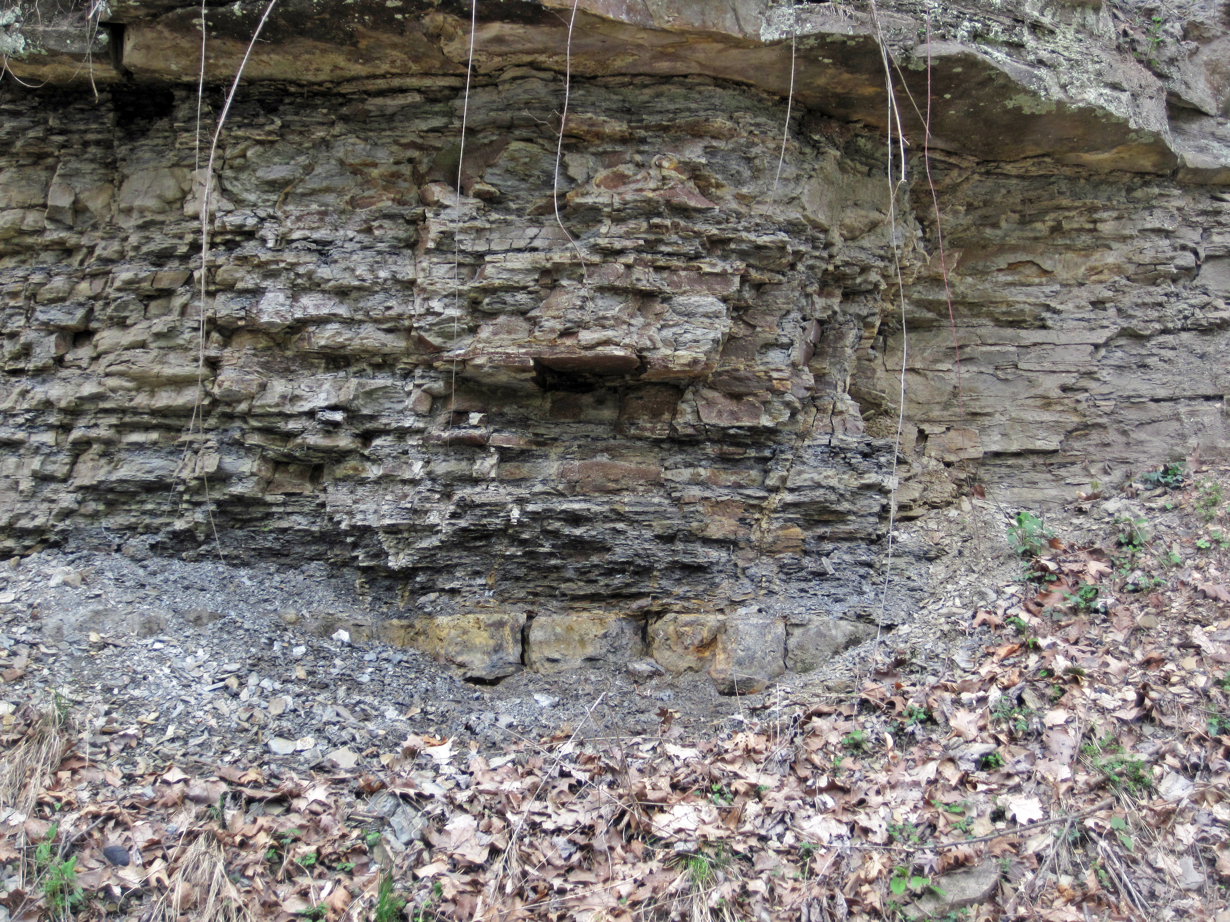
The Pottsville Group is a Pennsylvanian-aged cyclothemic succession containing nonmarine shales, marine shales, siltstones, sandstones, coals, marine limestones, and chert ("flint"). The lower Pottsville dates to the late Early Pennsylvanian. The upper part dates to the early Middle Pennsylvanian. The Lower-Middle Pennsylvanian boundary is apparently somewhere near the Boggs Limestone horizon (?). The ledge-like unit exposed just above the leaf-covered talus pile in the above photo is the Boggs Member, a relatively thin stratigraphic interval in the Pottsville Group. It typically consists of marine fossiliferous limestones, dominated by brachiopods and crinoid ossicles. Significant lateral and vertical lithologic variation is present - the Boggs interval ranges from being a fossiliferous limestone to an intraclastic limestone to a chert to a dolostone. In places, it has a relatively high component of disseminated pyrite. In other places, it is relatively rich in black manganese oxide(s). Minerals observed in the Boggs Limestone interval: calcite, dolomite, glauconite, goethite, gypsum, limonite, pyrite, sphalerite, turgite, vivianite, wad. At this site, the Boggs is principally a ferruginous fossiliferous chert/flint. The fossils and fossil fragments show up as light-colored specks in the rock (see: <a href="https://www.flickr.com/photos/jsjgeology/31215514761">www.flickr.com/photos/jsjgeology/31215514761</a>). This is the first locality where I ever observed the Boggs Member - it's a scrappy exposure for Boggs, although the site is excellent for seeing supra-Boggs stratigraphy. Blocks of ferruginous flint derived from the Boggs is scattered about as talus - this is one of two spots that have Boggs outcrop. Stratigraphy: Lower Mercer Limestone & Boggs Member, Pottsville Group, lower Atokan Stage, lower Middle Pennsylvanian Locality: Rock Cut railroad cut - outcrop along the southern side of Ohio Central Railroad tracks (west of milepost 134), ~southwest of Copeland Island & south-southeast of the town of Dresden, northern Muskingum County, eastern Ohio, USA |
| Data | |
| Fonte | Boggs Member (Middle Pennsylvanian; Rock Cut, Muskingum County, Ohio, USA) 1 |
| Autor | James St. John |
Licenciamento
- Você é livre:
- para compartilhar – copiar, distribuir e transmitir a obra
- para remixar – para adaptar o trabalho
- Sob as seguintes condições:
- atribuição – Você deve dar crédito apropriado, fornecer um link para a licença e indicar se as alterações foram feitas. Você pode fazê-lo de qualquer maneira razoável, mas não de maneira alguma que sugira que o licenciador endossa você ou seu uso.
| Esta imagem foi originalmente carregada no Flickr por James St. John em https://flickr.com/photos/47445767@N05/37351496202. Ela foi revisada em 8 de outubro de 2019 pelo robô FlickreviewR 2, que confirmou o licenciamento da imagem sob os termos de cc-by-2.0. |
Histórico do arquivo
Clique em uma data/horário para ver como o arquivo estava em um dado momento.
| Data e horário | Miniatura | Dimensões | Usuário | Comentário | |
|---|---|---|---|---|---|
| atual | 12h08min de 8 de outubro de 2019 | | 4 000 × 3 000 (5,48 MB) | wikimediacommons>Ser Amantio di Nicolao | Transferred from Flickr via #flickr2commons |
Uso do arquivo
As seguinte página usa este arquivo:
 " class="attachment-atbs-s-4_3 size-atbs-s-4_3 wp-post-image" alt="O que estudar para o enem 2023">
 " class="attachment-atbs-s-4_3 size-atbs-s-4_3 wp-post-image" alt="Qual melhor curso para fazer em 2023">
 " class="attachment-atbs-s-4_3 size-atbs-s-4_3 wp-post-image" alt="Enem: Conteúdos E Aulas On-Line São Opção Para Os Estudantes">
 " class="attachment-atbs-s-4_3 size-atbs-s-4_3 wp-post-image" alt="Como Fazer Uma Carta De Apresentação">
 " class="attachment-atbs-s-4_3 size-atbs-s-4_3 wp-post-image" alt="Como Escrever Uma Boa Redação">
 " class="attachment-atbs-s-4_3 size-atbs-s-4_3 wp-post-image" alt="Concurso INSS edital 2022 publicado">


_1_(37351496202).jpg)