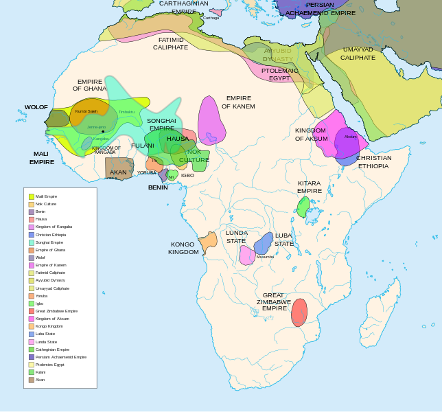
Imagem numa resolução maior (arquivo SVG, de 1 390 × 1 295 pixels, tamanho: 488 kB)
Este arquivo é do Wikimedia Commons e pode ser utilizado por outros projetos. Sua página de descrição de arquivo é reproduzida abaixo.
Índice
Descrição do arquivo
| DescriçãoAfrican-civilizations-map-pre-colonial.svg |
Africa History Atlas Diachronic map showing pre-colonial cultures of Africa (spanning roughly 500 BCE to 1500 CE) This map is "an artistic interpretation" using multiple and disparate sources. |
| Data | |
| Fonte | Trabalho próprio pelo carregador |
| Autor | Jeff Israel (ZyMOS) |
| Outras versões |
Obras derivadas deste arquivo: African-civilizations-map-imperial.png
|
Civilizations
These civilizations are shown on the map above
Mali Empire (done):
        [4], [5], [6], [7], [8](1300), 14

Nok Culture(done):
        http://perso.orange.fr/miltiade/Civilisation_de_Nok.htm
        [5]

Fulani empire (aka sokoto empire, Sokoto Calphate, Fulani Empire of Sokoto)  (fulani people are different) (done):
        [2], [10e], [11e]
Akan States (generric term for states with the akan people)(Done):
 [7],
Benin: (done)
        [7],[14],[16]
Hausa (done)
        [7], [10],[16]

Kingdon of Kangaba (1000AD?) (done)
        [8](1235)

Christian Ethiopia(done)
        [5]

Songhai Empire (done)
        http://commons.wikimedia.org/wiki/Image:Mapa_shonghai.svg
        [3], [4], [5], [6], [7], [8](1300), [16]
        http://www.zum.de/whkmla/histatlas/westafrica/haxmali.html
        http://empathosnationenterprises.com/Consulate/EN-Library/Black-Studies/afempire.html

Empire of Ghana (done):
        [4], [5], [6], [7]

Wolof: (15th century) (done)
        [2],[2c],[14]

Empire of Kanem:(done)
        [15]

Fatimid caliphate(done) 909-1171AD
        [2b],[6b]

Ayyubid dynasty (done) 1171-1250ad
        [1b], [5e], [6e]

Umayyad Caliphate (done) 661-750
        [5b]

Yoruba yorubaland    (done)
        [4b],[2c]

Igbo    (done)
        [4b],

Great Zimbabwe (done):
        [5], [7]

Kingdom of aksum (Axum?) 1bc-7ad  (done)
        [12b],[14b],[15b]

Kongo Kingdom     (done)
        [1c], [2c],[15]

Luba State (done) 15-19th century
        [2c],[4c]

Lunda State (done) 15-19th century
        [2c],[4c],[16]

Carthaginian Empire(done) (220BCE) Carthage
        [2c], [3c]

Persian Achaemenid Empire (done)
        [2e],3e].4e],[

THE PTOLEMIES (done)
        [8e], [9e]
Civilizations to be added
These civilizations have not been added because the borders have not yet been confirmed, or there is some uncertainty if they are a true civilization. Please add them to the map if you are able to define the borders of these civilizations.
Mane (1000-2000)(city) [41]

Kano (independent city-state) (1000-1903):
 [14]

Kaarta (kingdom of Kaarta) (1753-1854):
 [14]

Macina (Macina Empire) (aka Dina of Massina, Sise Jihad state, and Caliphate of Hamdullahi) (1818-1862):
 [14]

Segou (city 1620):
 [14]

Kingdom of Fouta Djallon (Futa Djalon or Kingdom of Fuuta Jallon):
 [14]

Hausa Bakwai (initial stage Hausa):
 [11e]

Wassoulou Empire (Ouassoulou) (1878 - 1898) :
 [14]

Kénédougou Kingdom (Kenedougou) (1650-1898):
 [14]

Ouagadougou (15th century CITY):
 [14]

Ashanti Kingdom:
	[14]

Dahomey:
	[14]

Gando (16th century town):
	[14]

kingdom of Takrur (c. 800 - c. 1285) :
	[8](1300), [13]

Oyo empire (1400-1796)


Bornu Empire (1396-1893):
        [2],[15], [10e]

Bornu-Kanem (a portion of kanem history where they merged):
	[7],[2c]

Wodaabe (a people of africa):
	[10]

Mamluk Sultanate of Egypt (1174-1820):
	[2],[12],

Kush?Kushite kingdom?:

Axum (see kingdom of aksum):

Buganda kingdom (changed to Unganda, but remained as Buganda people):

Lozi???:

Malawi Empire (late 15th centure and converted to Malawi Contry):

Kilwa (Kilwa Kisiwani, 9th century,  is an Islamic community is present day tanzania):
	[2c]

Abyssinia???:
        [2], [7]

Soha????:
        [2],

Nubia (Makuria, Nobatia, Alodia kingdom):
	[7],

Kingdom of Kerma(2500BC-1520BC):

=North Central=

Sahariano??:
	[1],

Maban????????:
        [1],

Fur(a people:
        [1],

Sudanes Central (language Central Sudanic):
        [1],

=East Central=

Sudanes Meridional???:
        [1],

Berta(language>:
        [1],

Kunama(a people):
        [1],

Komuz???instument:
        [1],

Aksumite Civilization
	[7b], [9b(maybey], [13b(aksum)]

Kingdom of Sheva???
	[8b]

Egypt
	[10b]

JolofEmpire (also called Dyolof or Wolof), wolof should be changed to this:
	[11b]


Meroe(city, capital of Kushitic Kingdom))
	[12b]

Bantu(ethnic group)
	[12b]

Khoisan(ethnic group)
	[12b]

Almoravid Empire
	[5c], [1f]

Monomotapa
	[2c],[16]

Lozi
	[2c]

Zulu Kingdom
	[2c]

Merina
	[2c]

Malawi
	[2c]

Rawanda
	[2c]

Buganada
	[2c]

Kazembe
	[4c]


Punt (3000BC-1000BC):
	location lost in time

D'mt (800BC-100BC):


Gudit (1000AD):

Zagwe Dynasty (1000-1268AD):
	[6e]

Solomonic dynasty (1270-1974AD)

Himyar:
	[1d]

Qataban:
	[1d]

Saba:
	[1d]

Hadhramaut:
	[1d]

Thutmoses 1
	[1e]

Ramesses II
	[1e]

Assurbanipal, empire of
	[7e]

Mbunda Kingdom
	[12e], [13e]
Editing this page and map
Suggestions before editing this map: Be sure to confirm it with multiple sources, and that it would be considered a true civilization. Also if you add to the map please name the layers and objects to keep it organized. A lot of the civilizations on this page do not have the times they existed. If this could be added it would be very beneficial. Then the map could be easily split into eras.
References
The original map came from
- Image:Africa map political-fr.svg, by Eric Gaba.
- some of the features where removed to simplify it.
- [1] http://www.proel.org/mundo/songhai.htm
- [2] http://afriquepluriel.ruwenzori.net/africa-atlas22.htm archive copy at the Wayback Machine
- [3] https://www.metmuseum.org/toah/hd/sghi/hd_sghi.htm
- [4] http://buckley6thgradehistory.pbwiki.com/AceWiki
- [5] "The Harper Atlas of World History", 1987, William Collins Son & Co Ltd, New York, pg131
- [6] https://www.ucalgary.ca/HIST/tutor/imageislam/westAfrica.gif
- [7] http://empathosnationenterprises.com/Consulate/EN-Library/Black-Studies/afempire.html
- [8] http://www.plu.edu/~allenjjj/img/The%20Mali%20Empire.jpg archive copy at the Wayback Machine
- [9] http://www.mythinglinks.org/afr~subsahara~HausaFulani.html
- [10] http://www.uiowa.edu/~africart/toc/countries/Niger.html
- [11] is [6b]
- [12] http://www.meitmuseum.org/toah/hd/maml/hd_maml.htm
- [13] http://www.uv.es/~ivorra/Historia/AEM/SigloXg.htm
- [14] http://www.zum.de/whkmla/histatlas/westafrica/haxmali.html
- [15] http://www.loyno.edu/~seduffy/MapImages/Africa1500-1800-display.jpg
- [16] http://www.flotte2.com/1800AD.htm archive copy at the Wayback Machine
- [1b] https://www.metmuseum.org/toah/hd/ayyu/hd_ayyu.htm
- [2b] https://www.metmuseum.org/toah/hd/fati/hd_fati.htm
- [3b] https://www.metmuseum.org/toah/hd/pave/hd_pave.htm
- [4b] https://www.metmuseum.org/toah/hd/pave/hd_pave.htm
- [5b] https://www.metmuseum.org/toah/hd/umay/hd_umay.htm
- [6b] http://countryturkmenistan.tripod.com/index.blog?from=20050708
- [7b] http://en.wikipedia.org/wiki/Image:LocationAksumiteEmpire.png
- [8b] http://www.imninalu.net/tribes2.htm archive copy at the Wayback Machine
- [9b] http://www.freewebs.com/eritrea2001/infocenter.htm
- [10b] http://www.iziko.org.za/sh/resources/egypt/history_new_kingdom.htm
- [11b] http://www.geocities.com/jbenhill/timeline.html
- [12b] http://p083.ezboard.com/Not-all-of-Africans-belong-to-Bantu-or-Negroid-race/fbalkansfrm57.showMessage?topicID=56.topic[link morto]
- [13b] http://www.homestead.com/wysinger/aksum.html
- [14b] http://news.asmarino.com/TomasMebrahtu/Images/Map_.jpg
- [15b] http://en.wikipedia.org/wiki/Image:GDRT230.jpg
- [16b] http://www.bible.ca/islam/islam-aksum-map-0-700ad.jpg
- [1c] https://www.metmuseum.org/toah/hd/acko/acko_d1map.htm
- [2c] http://exploringafrica.matrix.msu.edu/teachers/curriculum/m7b/activity1.php archive copy at the Wayback Machine
- [3c] http://www.livius.org/cao-caz/carthage/carthage.html
- [4c] http://concise.britannica.com/ebc/article-9370655/Luba-Lunda-states[link morto]
- [5c] http://www.allempires.com/forum/forum_posts.asp?TID=6586&PN=1
- [1e] http://www.iziko.org.za/sh/resources/egypt/history_new_kingdom.htm
- [2e] http://commons.wikimedia.org/wiki/Image:Achaemenid_Empire.jpg
- [3e] http://commons.wikimedia.org/wiki/Image:Carte_empire_ach%C3%A9m%C3%A9nide.png
- [4e] http://commons.wikimedia.org/wiki/Image:Persian_empire_490bc.gif
- [5e] http://commons.wikimedia.org/wiki/Image:Ayyubids1189.png
- [6e] http://commons.wikimedia.org/wiki/Image:Ayyubid.png
- [7e] http://www.fortunecity.com/tatooine/acegarp/898/10000bc601.htm archive copy at the Wayback Machine
- [8e] http://www.transanatolie.com/English/Turkey/Anatolia/Hellens/hellens.htm
- [9e] http://www.unc.edu/awmc/downloads/aegyptusPtolSml.jpg archive copy at the Wayback Machine
- [10e] http://www.amanaonline.com/Sokoto/table_of_content.htm
- [11e] http://www.britannica.com/ebi/art-3910?articleTypeId=1
- [12e] http://commons.wikimedia.org/wiki/File:Mbunda_Kingdom_Map.png
- [13e] https://www.mbundakingdom.org/
- [1x] http://commons.wikimedia.org/wiki/Image:Africa_15.PNG
- [2x] http://commons.wikimedia.org/wiki/Image:Africa_13.PNG
Licenciamento

|
É concedida permissão para copiar, distribuir e/ou modificar este documento nos termos da Licença de Documentação Livre GNU, versão 1.2 ou qualquer versão posterior publicada pela Free Software Foundation; sem Seções Invariantes, sem textos de Capa e sem textos de Contra-Capa. É incluída uma cópia da licença na seção intitulada GNU Free Documentation License.http://www.gnu.org/copyleft/fdl.htmlGFDLGNU Free Documentation Licensetruetrue |
- Você é livre:
- para compartilhar – copiar, distribuir e transmitir a obra
- para remixar – para adaptar o trabalho
- Sob as seguintes condições:
- atribuição – Você deve dar crédito apropriado, fornecer um link para a licença e indicar se as alterações foram feitas. Você pode fazê-lo de qualquer maneira razoável, mas não de maneira alguma que sugira que o licenciador endossa você ou seu uso.
- compartilhar igualmente – Se você remixar, transformar ou construir sobre o material, você deve distribuir suas contribuições sob a licença igual ou compatível como o original.
Legendas
1 maio 2007
image/svg+xml
458dcae2fb4eb4a66837ee9cd5c1e539750e7c18
498 775 Byte
1 295 pixel
1 390 pixel
Histórico do arquivo
Clique em uma data/horário para ver como o arquivo estava em um dado momento.
| Data e horário | Miniatura | Dimensões | Usuário | Comentário | |
|---|---|---|---|---|---|
| atual | 06h49min de 16 de fevereiro de 2024 |  | 1 390 × 1 295 (488 kB) | wikimediacommons>Ahiise2 | Changed "Bachwezi Empire" to "Kitara Empire" to be consistent with other versions of the file |
Uso do arquivo
As seguinte página usa este arquivo:
Metadados
Este ficheiro contém informação adicional, provavelmente adicionada a partir da câmara digital ou scanner utilizada para criar ou digitalizar a imagem. Caso o ficheiro tenha sido modificado a partir do seu estado original, alguns detalhes poderão não refletir completamente as mudanças efetuadas.
| Largura | 1390 |
|---|---|
| Altura | 1295 |


 " class="attachment-atbs-s-4_3 size-atbs-s-4_3 wp-post-image" alt="O que estudar para o enem 2023">
 " class="attachment-atbs-s-4_3 size-atbs-s-4_3 wp-post-image" alt="Qual melhor curso para fazer em 2023">
 " class="attachment-atbs-s-4_3 size-atbs-s-4_3 wp-post-image" alt="Enem: Conteúdos E Aulas On-Line São Opção Para Os Estudantes">
 " class="attachment-atbs-s-4_3 size-atbs-s-4_3 wp-post-image" alt="Como Fazer Uma Carta De Apresentação">
 " class="attachment-atbs-s-4_3 size-atbs-s-4_3 wp-post-image" alt="Como Escrever Uma Boa Redação">
 " class="attachment-atbs-s-4_3 size-atbs-s-4_3 wp-post-image" alt="Concurso INSS edital 2022 publicado">


